The portfolio and blog of David Bennett

Category: Mapping (Page 2 of 3)

Mapping Monday: Real-World Adventures

One of the things I liked about Aftermath’s Operation Morpheus is the idea of exploring Sydney University or a version thereof that’s been reimagined as a place for an adventure. Most of the adventure takes place in the (imaginary) bunkers underground, vast complexes of offices, labs, and facilities that have survived.

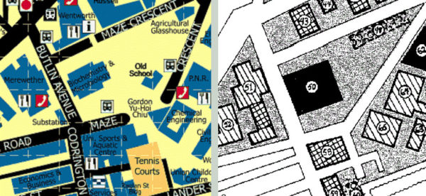
From a mapping standpoint, it’s great that there’s so much to explore, all mapped out and detailed enough to allow the gamemaster to easily expand upon. On the other hand, because it’s a game adventure, much of the detail and quirkiness of the corresponding real places has been ironed out. For example, the Biochemistry and Microbiology building is reduced to a square and smaller buildings have eliminated entirely.

The University of Sydney side-by-side real world and Operation Morpheus map details

For me, the real missed opportunity is that there’s no network of tunnels typical of many universities, at least in the United States. While the adventure layout means that the party must venture to the surface and gain access to other buildings to explore other complexes, navigating tunnels would allow for more three-dimensionality below the ground and provide additional smaller areas to explore. Perhaps I’ll try creating a map or two of my own to explore some of those ideas.

Mapping Monday: Maps with Screentones

Back when I wanted to be a published gamer, I submitted an adventure to Dungeon Magazine. It was my one and only submission and left something to be desired in terms of length of play and ways to draw the player in, being a foray into an adventure for TSR’s recently-published Oriental Adventures and being a little too heavily influenced by the adventures published for FGU’s Bushido, particularly Valley of the Mists. For the creation of the map accompanying the adventure, I wanted to create something that had a little more polish than my typical hand-drawn maps. I had been reading the Lensman manga, which I believe was the Moribi Murano version from the anime of the same name, and I learned about using screentone cut to shape to for shading. I duly made a trip to the University Bookstore and acquired sheets with the patterns I needed to fill the areas on my map with forest.

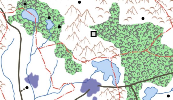
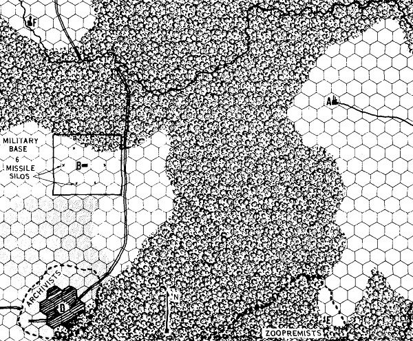
In this day and age, it’s far easier to accomplish the same effect digitally using texture fills or brushes with the designs you want. It’s also much less time-consuming than painstakingly cutting shapes using an X-Acto knife. I acquired old-school Letratone textures for forests, mountains, and more, created as tiles from scans of the original sheets by John Cooper. The look definitely evokes the feel of the original first-edition area map, but I think it works a little better in color. I’m not sure if it’s the feel I’m looking for on my Gamma World map I’m redesigning, but I love the look and the possibilities, so I may find another project to use it on.

Original 1st Edition Gamma World area map

Gamma World forest from original map

Mapping Monday: Gamma World Hex Maps

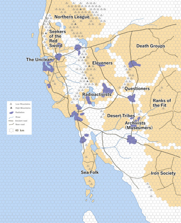
Creating and editing digital maps are great for repurposing maps on demand. I’ve never been fond of hex maps outside of their uses for wargaming, but I’ve enjoyed all the iterations of the maps in the various editions of Gamma World. The maps of the United States post-apocalypse are primitive, yet evocative of a shattered landscape populated by various cryptic alliances that, to me, are more interesting that those portrayed in something like the Morrow Project.

In my campaign, cryptic alliances exist as purely political divisions rather than something like as groups that may or may not control territory. A good example would be the Created, the alliance of androids that infiltrate other groups to further their own agenda. Though not shown on the map, I can imagine such a group existing in my world as a machine-dominated nation with human and mutated animal inhabitants who live alongside them with a philosophy like the Followers of the Voice, subservient to their metal masters.

Not shown on my map are the modern day locations what, to the typical Gamma World inhabitant, would be the ruins of the Ancients. In keeping with the style of the original 2nd Edition map, I also only showed the areas of direct influence of the different groups since it’s difficult to show overlap with the style (such as the disputed region that exists between the Eleveners and the Death Groups that is, instead, left entirely unshaded). I also primarily followed the hex grid for areas of influence since it flows more naturally around the mountains that naturally divide regions rather than following rivers.

Gamma World original campaign hex map showing political divisions and features

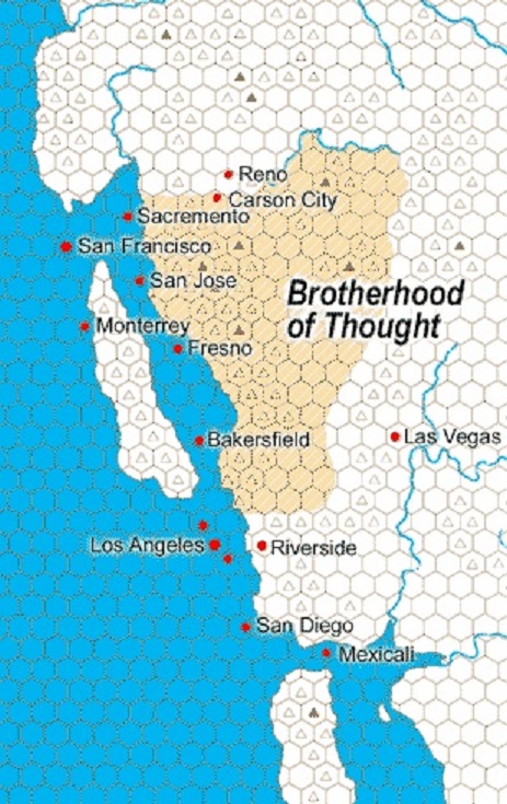
Gamma World 2nd edition west coast showing the Brotherhood of Thought cryptic alliance

Mapping Monday: Developing Cities

One of the more common issues I’ve seen with maps of cities in fantasy settings is their regularity. Short of a city being developed according to a master plan from the beginning or being rebuilt from scratch after a calamitous disaster, no city is going to be perfectly regular and even something like the Great Fire of London or the Kantō Earthquake still didn’t result in a uniform and elegant city design. There are many reasons for that, though I think the two chief reasons are human nature and natural features. People rarely relinquish their property, even if shaving off a hundred square feet on one side would allow a street to run in a straight line, and will rebuild on the same land, given a choice. For the same reason, rocky hills are notoriously hard to shift and rivers meander, so construction of houses and streets tend to conform to the landscape rather than vice-versa short of modern feats of engineering and, even then, only where the effort involved has a clear payoff. I live in Seattle and we’re quite familiar with the modern engineering that resulted in the Denny Regrade, whereby Denny Hill was leveled to allow for northerly expansion of the city. Even then, not everyone agreed to the plan and, like urban planners in modern China, the “spite mounds” in Seattle have their parallels with China’s “nail houses”.

Rules regarding cities may be thrown out the window in a fantasy setting and, as I’ve always thought, magic can substitute on some level for a degree of modern engineering. A sufficiently motivated dragon could substatially alter both the landscape and the disposition of human (or non-human) settlement in an area. Even more drastically, Japan’s legend of the yo-kai Namazu the Earthshaker was the cause of earthquakes and, if freed, could wreak much greater destruction and that’s just one of many beings around the world spoken of in myths and legends. Short of that, a more realistic city grounded int he real world is one that develops over time.

The typical settlement may develop at the bank of a river, atop an easily defended rocky outcropping, beside a sheltered bay, and many other such places that offer arable land, fish or game, or other ready source of food along with protections from storms and flooding or other natural disasters like fires, mudslides and volcanic eruptions. Even then, settlements may arise in inhospitable areas if that’s the only place to live close enough to rare resources like precious metals or gemstones. If the settlement exists along a trade route or main path of travel (for example, as a seaport conveniently located as a stopover point), it may grow. As it does, walls and fortifications develop and other structures are added to facilitate travel, trade, and mercantilism. Increasingly, housing for permanent and transient populations multiply and entertainment venues also develop. In a planned sense, a Roman settlement offers all of these, typically following a fairly uniform plan with a fortified camp, a forum and basilica, an amphitheater, several temples, markets, and bathhouses, all enclosed by a wall. As cities grow, they often incorporate other settlements and expand beyond the bounds of their original walls. Those existing structures may constrain development much the same way natural land features do.
Ankh Morpork river crossing thumbnail by Charles D. F. Board

For all of the reasons enumerated, I think it’s great when an experienced urban planner offers up his rendition of the evolution of Terry Pratchett’s Ankh Morpork. Not only does it offer some great insights into how the great circular city might develop, but it allows for comparison to a similar riverine city like London from its beginning as a Roman settlement to its later habitation during Anglo-Saxon times and its later fortification in the Middle Ages.
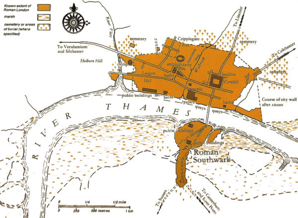
Roman London known extent with major structures
Mapping Monday: Artful Maps by Elizabeth Person

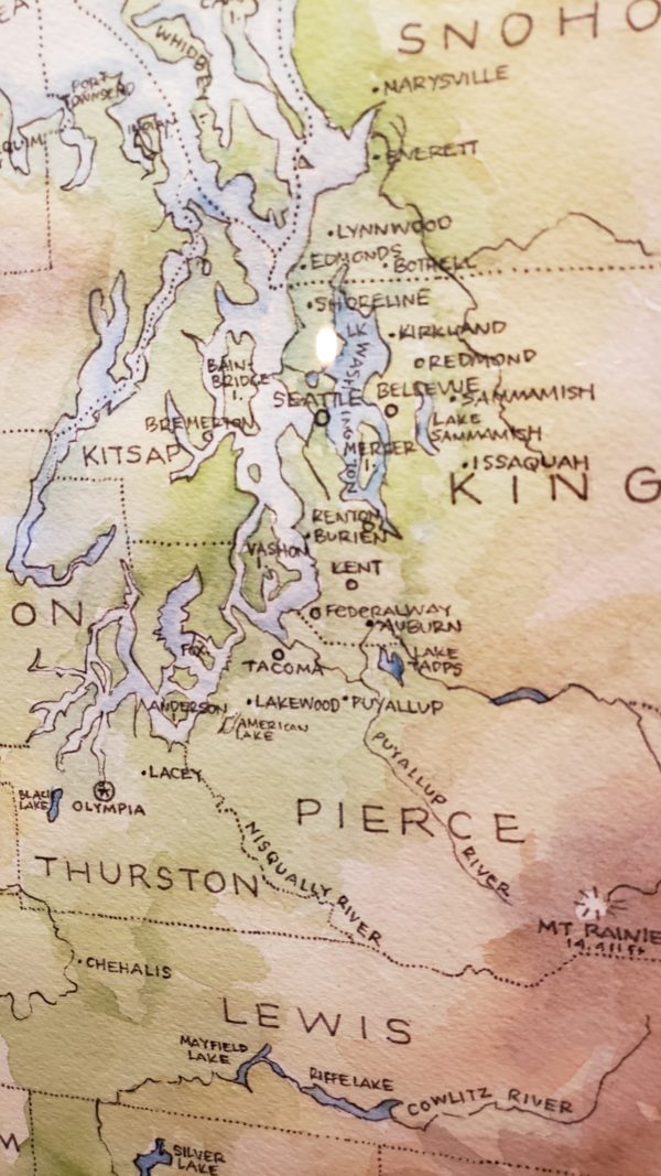
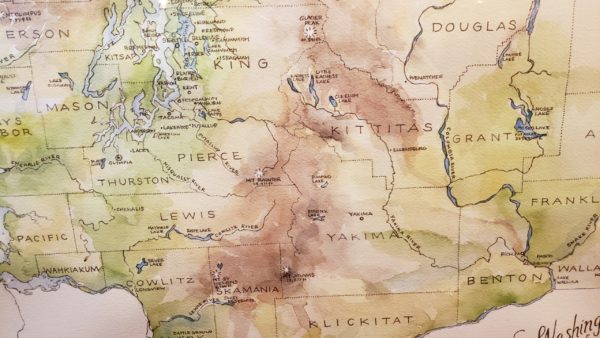
There’s nothing better than going out for the evening to a local pub and enjoying art on the walls in the form of beautiful maps by a local artist. These are one of my favorite kinds of maps and I love the hand-lettering. The colors convey a great deal of depth and the variety of the terrain the map illustrates. You can find more of Elizabeth Person’s work on her site.

Washington Map by Elizabeth Person – Puget Sound detail

Washington Map by Elizabeth Person – Cascades detail

Mapping Monday: Man-made Features

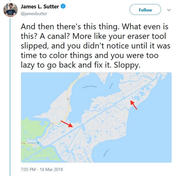
Truth is always stranger than fiction and never more so than when looking at maps of places that have been touched by human hands. Filling swamps for warehouses and dredging of rivers for the passage of boats, as just one example, results in highly regular looking waterways and coastlines. Which is why a recent Twitter thread by James L. Sutter about New Orleans is so entertaining. The canal he points out particularly caught my attention because it’s such an absurd feature, but it’s part of a set of features that constitute the Gulf Intracoastal Waterway and it joins up with the Industrial Canal and the Mississippi River – Gulf Outlet Canal, where all three waterways allow traffic between Lake Ponchartrain and different parts of the Gulf.

New Orleans canal – James L Sutter tweet

That’s neat and all, but not so relevant to a fantasy setting that posits a High Medieval level of technology, even with the addition of magic and perhaps some manner of gargantuan beasts to assist with engineering tasks like dredging. But features like this, all criticism about “realism” aside, make for some fascinating visual accents and the most efficient way of moving people and goods is in a straight line. So if justifying canals in a straight line covering many tens of miles seems problematic and your setting doesn’t have the remains of some sort of advanced empire or forerunner civilization, consider an application of what exists in the setting. A nation with advanced engineering know-how can overcome a great deal of obstacles to built impressive roads, particularly in areas that are relatively flat, such as the roads built by the Romans in southern England. A large population dedicated to a single task, either united by a cause or enslaved to a smaller group of overseers, might overcome their deficit of expertise by simple brute force. Think, for example of the underground highways of the dwarves or the similar passages carved by Drow thralls in a traditional fantasy setting.

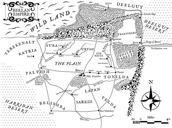
No matter what you do, creativity is the key and don’t limit your maps through lack of imagination. Conversely, I’ve seen so many maps of allegedly fantastic places that look like they were laid out by robots, ignoring terrain features and the simple wherewithal of the inhabitants to construct these ruler-straight roads and waterways. It’s the reason I hate the map of the Beklan Empire from Shardik by Richard Adams where roads and rivers often run in straight lines including one road that inexplicably arc from north to east in order to cross a river three times for no readily-apparent reason. In fairness, it’s been some time since I read the book, so I can’t recall if any of the setting features or origins are logically explained.

Beklan Empire from Shardik

Mapping Monday: Underground Redoubts

Way back when, I drew more than a couple of maps of underground fortifications. They were undoubtedly heavily influenced by the original D1 Descent into the Depths of the Earth adventure and the others in that series. In many cases, I conceived of guardposts like this being fortifications built by dwarves or humans, keeping in mind that this was long before the in-depth writings and background on the Underdark and on things like the architecture of Drow cities.

The first two maps are a completely underground set of fortifications with the upper levels excavated beyond the main tunnel blocked by the fortifications. The third map is a fortification at the mouth of a tunnel to the outside that could lead to a settlement that could either be completely underground or above ground and only reachable by a tunnel (such as within the caldera of an extinct volcano or atop a rocky tor).
Continue reading

Mapping Monday: Redrawing Old Maps

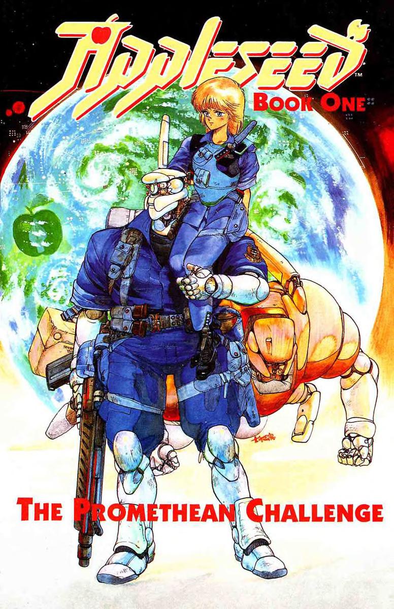
Appleseed: The Promethean Challenge cover

Back in the day, I did a map for an adventure I had written and meticulously drew out the map by hand. At the time, I was reading the Appleseed manga and I was enchanted by the shading done with screentones that are cut to fit and applied to the drawing. So I went and duly acquired the sheets I needed from the University Bookstore. These days, with the advent of computers, a similar effect can be applied when creating or editing on the computer and there’s a variety of freely available screentone brushes available for that purpose. If I were to rework that map, I would definitely do those sorts of things digitally.

In a similar spirit, I took it on myself to try out some techniques using GIMP and redrew the maps from my Gamma World campaign, combining the two campaign maps. There’s some great information on creating digital maps and most techniques that apply to Photoshop work equally well for GIMP. In most cases, Photoshop brushes transfer well, which can be a lifesaver. In the case of my map, I was prepared to build my own and I’m still not entirely sure I like the aesthetics of what I used, though these mountain brushes are fantastic and come in three different flavors (outline, shaded, and patterned).

Continue reading

Mapping Monday: Villains and Vigilantes

In another set of campaign maps, these were created for a series of adventures I ran in a shared universe where we traded off gamemastering duties and, at least at one point where the group had grown too large to sustain, split into multiple groups. This set of adventures was originally created to be run with the Villains and Vigilantes rules from FGU before we later migrated to Superworld.

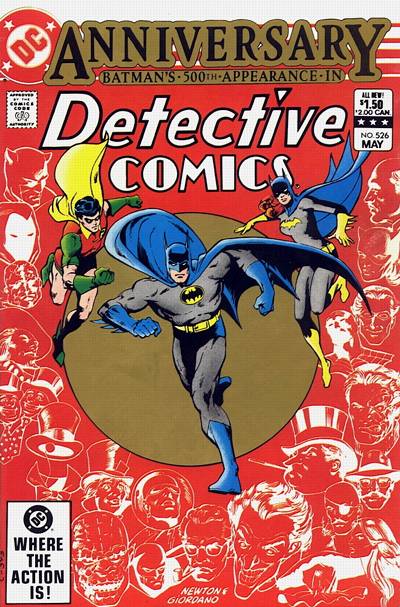
Detective Comics #526 commemorating Batman’s 500th appearance

The flavor was intended to be street-level with settings heavily influenced by the Batman story, “All My Enemies Against Me”, in Detective Comics #526. In addition to the idea of different villains working together in groups, there was also the idea of the city being divided into areas controlled by different gangs with different plots in motion that the heroes needed to foil but, since the villains were working together, those plots interlocked and led from one to another. The maps themselves consisted of a large city map with various local maps that, in retrospect have elevations that I suspect were influenced by the Marvel Super Heroes game battle maps and by the map of Midville included in Car Wars, both of those being purpose-built maps with layouts suited to the types of gameplay those games favored. Curiously, at least the area I mapped seems to be zoned almost entirely for one- and two-story structures.

Continue reading

« Older posts Newer posts »

© 2025 Gaslight & Steam

Theme by Anders NorenUp ↑